


Chateau de Joux et Fort Malher

csy95
User
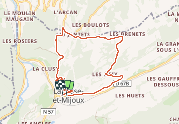

Length
8.8 km

Max alt
1111 m

Uphill gradient
260 m
Km-Effort
12.3 km

Min alt
863 m

Downhill gradient
258 m
Boucle
Yes
Creation date :
2025-02-09 12:57:50.918
Updated on :
2025-02-09 15:03:31.765
2h05
Difficulty : Easy

FREE GPS app for hiking
 SityTrail
IGN / Geographical institutes
SityTrail Plus
The world is yours!
About
Trail Walking of 8.8 km to be discovered at Bourgogne-Franche-Comté, Doubs, La Cluse-et-Mijoux. This trail is proposed by csy95.
Positioning
Country:
France
Region :
Bourgogne-Franche-Comté
Department/Province :
Doubs
Municipality :
La Cluse-et-Mijoux
Location:
Unknown
Start:(Dec)
Start:(UTM)
300326 ; 5194294 (32T) N.
Comments